HOME PAGE
WHAT'S NEW?
JUNIOR PAGE
COACHING
WHAT IS
ORIENTEERING?
GALLERY
MAPPED AREAS
EVENTS DIARY
RESULTS
SOLUS
CLUB POLICIES
HOW TO JOIN
LINKS
COMMENTS FORM

THE HEADLESS CHICKEN PAGES
Kirkhill
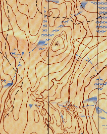
Grid Reference NX 087 754
Surveyed and mapped in 1998.
Land privately owned.
The land shape on this map is of a bowl with farmland in the centre and a wide ridge that encloses it on three sides. There are some complex contour details on sections of the ridge and some mature woodland pockets on others. Hence this area tests orienteering skills in a number of varied types of terrain. It was first used for the Scottish Championship relays in 1999.
@ Crown Copyright. All rights reserved. PU 43423U. BOF Map registration number:- SO-99-352