HOME PAGE
WHAT'S NEW?
JUNIOR PAGE
COACHING
WHAT IS
ORIENTEERING?
GALLERY
MAPPED AREAS
EVENTS DIARY
RESULTS
SOLUS
CLUB POLICIES
HOW TO JOIN
LINKS
COMMENTS FORM

THE HEADLESS CHICKEN PAGES
Mapped areas in Dumfries
Crichton Grounds and Dumfries and Galloway College
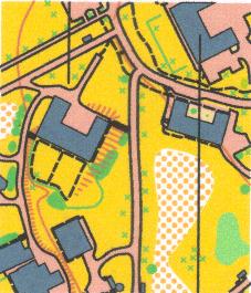
Grid reference NX 983 742
Produced on OCAD in 2000. Map extended and revised March 2010. Updated 2011.
Numerous buildings set in open areas with a scattering of bushes and mature trees characterise this area. This environment makes a good introduction to those new to the sport as there are many easily identified features. For the more experienced runner it enables fast running, but there is sufficient complexity to catch out the speed merchant whose concentration lapses. An ideal area for park orienteering.
@ Crown Copyright. All rights reserved. PU 43423U. BOF Map registration number:- SO-10-1006
Castledykes Park
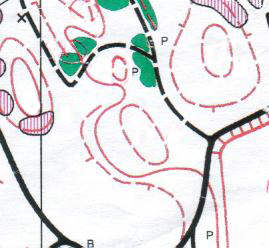
Grid reference NX 97 74
Revised and produced on OCAD 2001. Updated 2017
This is a small enclosed area and the high level of detail on the map makes it ideal for score or map memory events. Younger orienteers have to face the distraction of a good play area in the park.
@ Crown Copyright. All rights reserved. PU 43423U. BOF Map registration number:- SO-01-352
Georgetown Street Map
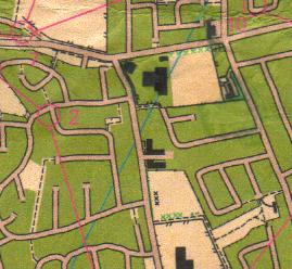
Grid reference NX 988 750
Map updated 2001 and produced on OCAD.
Anyone who knows Georgetown will have experienced the rabbit warren of interconnecting pathways and roads. Many experienced orienteers can testify to the difficulties presented by this area - especially when oxygen debt is added to the equation. An ideal setting for street orienteering and the periphery even allows some running alongside open fields.
@ Crown Copyright. All rights reserved. PU 43423U. BOF Map registration number:- SO-01-353