HOME PAGE
WHAT'S NEW?
JUNIOR PAGE
COACHING
WHAT IS
ORIENTEERING?
GALLERY
MAPPED AREAS
EVENTS DIARY
RESULTS
SOLUS
CLUB POLICIES
HOW TO JOIN
LINKS
COMMENTS FORM

THE HEADLESS CHICKEN PAGES
Drumlanrig Woods
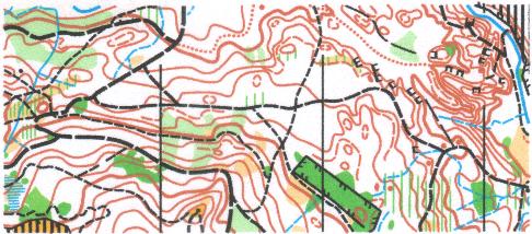
Grid Reference NX 852 993
First surveyed and mapped in 1988, revised in 1993. Resurveyed 2006. Updated 2008 and 2012
These woods are part of the Buccleuch Estate. A system of paths weaves its way through the trees - a pleasant mixture of coniferous and deciduous - and ensures enjoyable orienteering for the competitors on the shorter courses. Those on the longer courses will be challenged by that same system of paths which has been known to catch out the unwary. Contour detail such as re-entrants, spurs, pits and gullies add to the navigational interest.
@ Crown Copyright. All rights reserved. PU 43423U. BOF Map registration number:- SO-07-780