HOME PAGE
WHAT'S NEW?
JUNIOR PAGE
COACHING
WHAT IS
ORIENTEERING?
GALLERY
MAPPED AREAS
EVENTS DIARY
RESULTS
SOLUS
CLUB POLICIES
HOW TO JOIN
LINKS
COMMENTS FORM

THE HEADLESS CHICKEN PAGES
Dalbeattie Town Wood
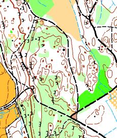
Grid Reference NX 837 599
First surveyed and mapped in 1981, updated and revised in 1995. Map re-drawn March 2010. Updated 2012.
Owned by Forest Enterprise
The forest has an extensive system of paths, however once off these paths there are some demanding areas of contours and the abundance of rocky out crops and crags can confuse the unwary. Recent felling and wind blown areas have had an impact on orienteering but it is still possible to set challenging courses at all levels.
@ Crown Copyright. All rights reserved. PU 43423U. BOF Map registration number:- SO-09-987