HOME PAGE
WHAT'S NEW?
JUNIOR PAGE
COACHING
WHAT IS
ORIENTEERING?
GALLERY
MAPPED AREAS
EVENTS DIARY
RESULTS
SOLUS
CLUB POLICIES
HOW TO JOIN
LINKS
COMMENTS FORM

THE HEADLESS CHICKEN PAGES
Byreburn
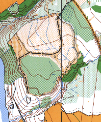
Grid reference NY 390 780.
First surveyed in 1983, re-surveyed in 1999 using OCAD.
Byreburn Wood next to Canonbie is our most eastern mapped area. It is one of those interesting little woods that always seem to be much larger than they are, on account of the variety of terrain and vegetation. Well provided with paths and line features the map is ideal for youngsters, while the deep valley that bisects the area and other varied terrain provides a challenge for everyone. The old railway viaduct, which crossed the gorge, was spectacularly demolished with explosives a few years ago. The line of the old railway is still evident on the map.
@ Crown Copyright. All rights reserved. PU 43423U. BOF Map registration number:- SO-98-258