HOME PAGE
WHAT'S NEW?
JUNIOR PAGE
COACHING
WHAT IS
ORIENTEERING?
GALLERY
MAPPED AREAS
EVENTS DIARY
RESULTS
SOLUS
CLUB POLICIES
HOW TO JOIN
LINKS
COMMENTS FORM

THE HEADLESS CHICKEN PAGES
Ae Forest
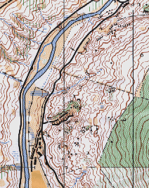
Grid Reference NX 98 92
Surveyed and mapped in 1990.
Owned by Forest Enterprise.
Since mapping the forest has reached the stage where some harvesting is planned and there has been some felling. However, the more complex areas remain forested and prove a stiff challenge both for the navigation and for the strength needed in the legs. The mapped area covers two sides of a valley and a little bit of track running on one side is inevitable - that interlude needs to be put to good effect because of the contour detail at both ends of the track.
@ Crown Copyright. All rights reserved. PU 43423U. BOF Map registration number:- 0082SO