HOME PAGE
WHAT'S NEW?
JUNIOR PAGE
COACHING
WHAT IS
ORIENTEERING?
GALLERY
MAPPED AREAS
EVENTS DIARY
RESULTS
SOLUS
CLUB POLICIES
HOW TO JOIN
LINKS
CONTACT US

THE HEADLESS CHICKEN PAGES
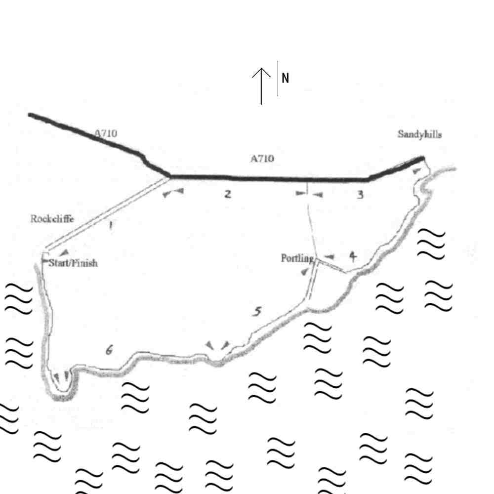
Rockcliffe to Rockcliffe - a training option.
The route below is one that we have used for training, albeit normally only on reasonable days, as it combines distance, hills, off road running, splendid views, interesting flora and fauna and the opportunity for us to start from different points and finish at roughly the same time.
Finish point:
Rockcliffe car park (just before reaching the coast).
Start points:
Rockcliffe car park for the full 8.5 mile route.
Sandyhills for the 5.5 mile route.
Portling triangle for the 4 mile route.
There are a variety of start points depending on how long you wish the run to be but remember that you will need two cars if the start and finish points are not the same. Every route starts with an uphill section so you will need to warm up well before starting.
Route Description.
The real delight in this run comes in the section along the coast, so the aim in the circular long route is to deal with the road section first. The route is divided into a number of segments.
Turn right at the road on leaving the car park, forget that you have just driven down to get here and allow yourself to be distracted by the llamas and then the picturesque church as you climb the mile back to the main road.
Turn right at the T junction and head towards Sandyhills - mind needs to be in neutral here.
Avoid the temptation of the Portling short cut (or take it if your legs are telling you something already) in the knowledge that it is now downhill all the way to Sandyhills. Turn right at Sandyhills through the car park, onto the beach and then head for the bridge at the west end of the beach. Cross this and carry on the path in front of you. Yes it is uphill and it will continue so for a while. Keep to the seaward edge of the field up to the observation point (a rest here is well deserved) and then descend towards Portling. Some of the stepping platforms in the walls are well disguised. Head up the road to the Portling triangle. One hill completed.
Take the left turn at the triangle (uphill!) and as the track descends towards the sea there is a sign (Rockcliffe) and some steps in a wall on the right.
Cross here and climb number 2 starts. This one is stiff so a little break to admire the view is permitted. Beware the descent on the other side, particularly if wet, as it is rather slippy. Some folks change to O shoes at Portling. Continue on the path that runs along the top of the cliffs until just before the monument.
The next section is flat to start with - a good time to regain your breath as eventually you scale the side of Barcloy Hill. Follow the path near the prominent wall up the hill (the low level route looks attractive initially but is awful at the end) until the wall turns inland where you keep going west, descending to a quick visit to Castle Point. For the last leg it is time to summon up energy reserves for a display of vitality and good health as you head for Rockcliffe along the normal tourist track from Castle Point. Then at the road you turn right and have a mere 60 Yards left to the car park (uphill though).