HOME PAGE
WHAT'S NEW?
JUNIOR PAGE
COACHING
WHAT IS
ORIENTEERING?
GALLERY
MAPPED AREAS
EVENTS DIARY
RESULTS
SOLUS
CLUB POLICIES
HOW TO JOIN
LINKS
CONTACT US

THE HEADLESS CHICKEN PAGES
Distance Judgement.
In the last article on orienteering technique you will recall that traffic light orienteering was discussed. This basic tool can form the framework which enables orienteers to use other techniques and skills which aid navigation.
One simple way to cut down on errors is to be accurate in distance judgement. Without this skill testing navigational challenges assume almost impossible proportions. If you watch the really good orienteers they just seem to know when they have covered enough ground. Few of us are born with this ability and it is only through hard work and practice that this "6th sense" is acquired. So how to improve? Well the easiest way is to mark out 100 meters and then walk or run along it counting your paces as you go. (N.B. Most orienteers count their paces as the Romans did by counting every 2nd step.) Very simple, I hear you say. Well, yes and no. You have to bear in mind that a 100 meters going along a level track will require a different number of paces from the same distance going up or down hill. Similarly going through undergrowth, running , walking and how tired you are will all have an affect. Practising in different conditions will give you a feel for how that number varies.
While this may initially seem alien, for many orienteers pacing gradually becomes second nature and is used constantly - what you thought was exhausted mumbling is probably 'fifty seven, fifty eight...'. Also when running on unfamiliar terrain it can help make the map "fit". This is especially true if the terrain is very complex where knowing the distance covered assists in identifying the smaller features and hence keeping in touch with the map. If there is a section of track running, pacing will help to prevent over or under estimation of the distance covered. Pacing is important if you are heading down a track or ride which peters out and you are intending to use the track or ride in your navigation - the location of the end of such a feature may have moved since the map was drawn and it will be important to have a feel for this.
Pacing should be used in conjunction with other orienteering techniques and these will be covered in future articles.
However a word of warning, pacing has its limitations. It is not 100% accurate (an error of 10% is typical), thus it follows the longer the distance paced the greater the inaccuracy. Whenever possible you should use distinctive features to confirm your position and restart counting from zero. It is also worth remembering that in some situations pacing is of little use e.g. on very steep or extremely rough terrain.
Club members who are interested in practising pacing should contact Tim for details of where they might practise (accurately measured sections of tracks.)
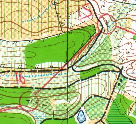
@ Crown Copyright. All rights reserved. PU 43423U. BOF Map Registration No. 0225SO
Route choice between 15 and 16 involves making your way to the track junction crossing to the next track (going due south at this point) then 150 meters along it, followed by turning into the dense undergrowth and heading up the hill to the ridge. The definite vegetation change shown on the map there was not definite to many of us who visited the area, so the distance measurement was crucial.
In this case pacing will allow you to stay in touch with the map while you cross the ground following a compass bearing. First of all, pace to the stream in the marsh and then keep pacing as you head upwards – if you have drifted to the north you will reach the hill summit too soon (that is the wrong one). After crossing the correct summit, pacing is still important as smaller marshes might not be easily recognised if the weather has been dry.
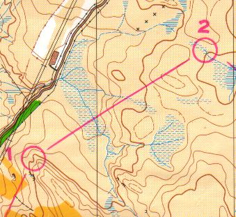
@ Crown Copyright. All rights reserved. PU 43423U. BOF Map Registration No. 0019SO