HOME PAGE
WHAT'S NEW?
JUNIOR PAGE
COACHING
WHAT IS
ORIENTEERING?
GALLERY
MAPPED AREAS
EVENTS DIARY
RESULTS
SOLUS
CLUB POLICIES
HOW TO JOIN
LINKS
CONTACT US

THE HEADLESS CHICKEN PAGES
Contours - The shape of things.
Over time many features on maps change. Trees can be felled, tracks become over grown, new houses built .... but generally the shape of the land does not alter greatly. It takes a major event to make significant changes to the bumps and hollows of the land. Given this situation you would think that using land forms would be orienteers' first choice for aiding navigation. So why is this not so? Perhaps because contour lines tend to fade into the back ground when compared to roads, rivers and other clearly defined features. Also it takes time and practice to be confident in reading contour lines and let's face it, it is not easy reading a map while running.
So how good are you at interpreting the contour lines on an Orienteering map? Do all those brown squiggly lines just look as if some one has been careless with a bowl of spaghetti? If you can quickly and confidently distinguish high land from low and spurs from re-entrants just by looking at a map you probably have a reasonably good grasp of what is involved. However making full use of this information in the heat of the race is much more difficult and many orienteers aren't completely successful. You will know if you are in this category if you:-
1) habitually navigate using line features even when this can involve a long detour.
2) always get a sinking feeling when you see the map you are about to run on is lacking in line features but has a plethora of brown lines.
3) routinely have problems when orienteering in unfamiliar forests where the map is old and there are many discrepancies between the map and the land.
The benefits of being able to read contour lines are many. At the most basic level they show the shape, height and steepness of the land. Here is some basic information about them:-
1) If you look closely at an orienteering map you will discover that every 5th contour is marked with a slightly thicker line. These are called index contours. They are there to help calculate heights - it is all too easy to lose track of which line has been counted when all lines are the same thickness.
2) You will find that most orienteering maps have a contour interval of 5 meters. (This information is usually found close to the scale of the map.) This means that the space between one contour line and another represents 5 meters in height when translated onto the ground. Consequently if the lines are densely packed we can surmise that the ground rises steeply and conversely if there are large gaps between the lines then the ground is much flatter. Thus some impression of height and steepness of the terrain is imparted even to the casual map reader.
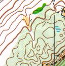
To use contour lines you need to be able to distinguish high land from low land. This can be a useful skill when making route choices. If faced with two technically similar route choices of comparable length, one with little climb and a second with substantial climb, it is sensible to opt for the less physically demanding option. Look at the following sections of map to see the differences between high and low land. In the first you will notice that the contour lines form closed loops. This represents a rise of 15 meters.

@ Crown Copyright. All rights reserved. PU 43423U. BOF Map Registration No. 00101SO
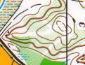
In the second example the initial impression is that this is also a hill but if you look closely you will notice that there are small lines pointing into the centre of the area enclosed by the contour lines. These are called tag lines and are used to show low land (the tags always point to the low land and will appear on any contour line which is below the level of the surrounding land ). This example shows a depression 15 meters deep and 70 meters long.

@ Crown Copyright. All rights reserved. PU 43423U. BOF Map Registration No. 0101SO
Building on this information the next step is to work on identifying spurs and re-entrants - another area which frequently causes confusion. This example shows a re-entrant. You can see that the contour lines form a "u" shape. Note that the bottom of the "u" points towards the high land. In some cases identification of re-entrants is made easy by the presence of a stream running through it - streams never run along the ridge of a spur.
@ Crown Copyright. All rights reserved. PU 43423U. BOF Map Registration No. SO-01-360
The next section of map shows a spur. This is also a "u" shape but this time the base of the "u" points away from the high land.
@ Crown Copyright. All rights reserved. PU 43423U. BOF Map Registration No. SO-01-369
Once you become confident in reading contour lines it becomes easier to visualise what the terrain will look like and awareness of deviations from your chosen route occurs more quickly. From this it is a short step to using land forms to aid navigation by using them as
· "hand rails" to lead you to your control,
· collecting features behind the control,
· an attack point to assist in locating the control.
This is a complicated topic and this article is really just a starter: more details and specific examples will appear in future articles. To whet your appetite here are two more sections of map - see if you can work out what features the controls are on. The answers are at the very bottom of this article.
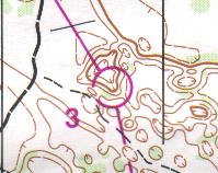
@ Crown Copyright. All rights reserved. PU 43423U. BOF Map Registration No. 0101SO
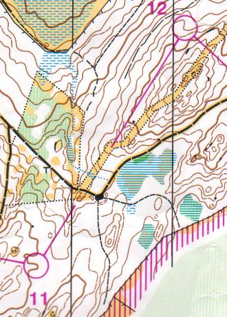
@ Crown Copyright. All rights reserved. PU 43423U. BOF Map Registration No. 0172SO
Answers
3 Depression.
11 Spur.
12 Re-entrant.