HOME PAGE
WHAT'S NEW?
JUNIOR PAGE
COACHING
WHAT IS
ORIENTEERING?
GALLERY
MAPPED AREAS
EVENTS DIARY
RESULTS
SOLUS
CLUB POLICIES
HOW TO JOIN
LINKS
CONTACT US

THE HEADLESS CHICKEN PAGES
Bearings
part 2
Taking and using bearings are important elements in an orienteer’s tool kit, especially when the navigation is in more complex terrain. This article will look at some of the ways in which bearings can be used: as with all navigation techniques bearings have their limitations - these will also be covered.
Here are some situations in which you might choose to take and use bearings.
1 Crossing a block of land.
This is perhaps the most obvious time to use a bearing. By using this technique you are able to move quickly across the terrain whether it is complex or the features are less distinct. In the example shown the junction of the two paths close to control 9 can be used as a catching feature and will enable you to switch from rough navigation skills to more precise ones. This approach can also be used when the catching feature is located behind the control site. (On the day the paths were indistinct and it was the bearing plus pace counting that led to the control being found).
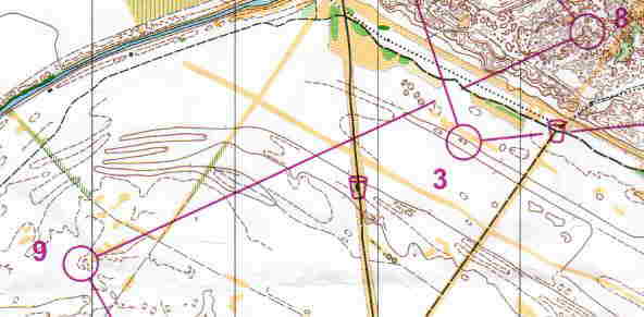
@ Crown Copyright. All rights reserved. PU 43423U. BOF Map Registration No.SO-99-276
2 Aiming off.
In this example do not take a direct bearing on the control site. Instead consciously aim off a few degrees to the right of the control. This will ensure that you know which way to turn when you reach the forest track / ride.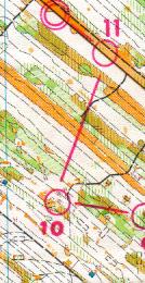
3 Checking the alignment of a linear feature.
When crossing a block of forest, check the direction of linear features that you encounter. This can help you to become aware of any deviations from your planned route which you may inadvertently be making. In this example the track before control no 4 changes direction sharply. By taking a quick bearing along the path you can establish whether you have hit the path where you planned or if you need to take any corrective action.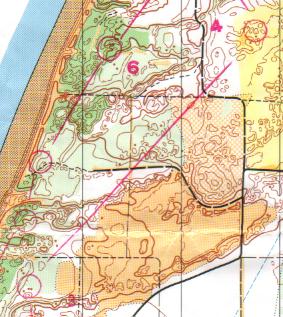
@ Crown Copyright. All rights reserved.
PU 43423U. BOF Map Registration No.SO-99-276Used wisely bearings can be very useful and help you successfully to solve some tricky navigational problems but they also have limitations to be wary of.
These include-
1. It is impossible to be 100% accurate on a bearing. The degree of error will increase if the ground you have to cross is rough and there are obstacles to climb over and go round.
2. Also the further you follow a bearing the greater the actual distance you go off course for the same error in a bearing.
@ Crown Copyright. All rights reserved.
PU 43423U. BOF Map Registration No.0172SO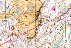
@ Crown Copyright. All rights reserved. PU 43423U.
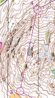
BOF Map Registration No.SO-01-3693. Beware if your route choice requires you to contour around the side of a hill. Do not use a bearing after contouring unless you have a definite feature that confirms where you are on the hill side. It is all too easy to head off in the wrong direction. Look at the last two examples. In the first there are no distinctive features to tell you where you are on the hillside so it would make more sense to go up and over the hill rather than take the less physical option of going round.
In the second map section there are features that can be used to confirm your position i.e. you will pass the end of crags, which cut back round in a distinctive way and on your left there is a spur with a knoll on top. Hence you can pinpoint your position and make good use of a bearing from the crag foot as the method of finding the control. If you take a bearing when you are unsure about your position on the map it will be a minor miracle if it helps you in accurate rather than rough navigation.
To help offset these negative points use bearings in conjunction with other navigational techniques such as pace counting and visualisation.